by Brian Roulston
Today, Port Dover is a favorite summer-time destination among Hamiltonians looking to escape the heat and get away from the big city. One can spend a few hours or an afternoon enjoying the beach, the sunshine, and the cool breezes off Lake Erie. Enjoy a foot-long hotdog or a platter of Lake Erie perch at one of the town’s many restaurants or take-out establishments. It takes roughly an hour to travel via Upper James and Highway 6 from the foot of James Street to Port Dover on Lake Erie’s North Shore.
Highway 6 is now one of the longest routes in the province, running from Nelson Street in Port Dover to the Trans-Canada Highway and Highway 17 in Espanola, a distance of 480 kilometers or 300 miles. In this article, we will talk about Highway 6 between Hamilton and Port Dover. The road became a highway in 1920, five years later it got its number designation as King’s Highway #6.
Port Dover was once a part of the London District. In November 1833, the London District and the Gore District petitioned the Government of Upper Canada to construct a road to transit Mt. Hope over the Grand River, then on to Port Dover. Permission to build the road came in March 1834. That summer, Ranald MacKinnon, a Scotsman more famously noted for his tavern in Caledonia called ‘The Haldimand House’ did a survey of the region. He was also the contractor between Hagersville and Port Dover then Caledonia to the Mountain Brow for what would become the Hamilton-Port Dover Plank Road in 1839. John Van Norman Construction Company of Simcoe, Ontario, was contracted to build the plank road between Hagersville and Caledonia. The Government of Upper Canada asked that the road not pass through any crop fields or orchards andy stipulated buildings were not to be torn down or moved without permission from the landowners. The road was finished in 1843 and opened to the public in 1844. This plank road was originally 76 km (47 mi) long and the cost of construction at the time was $156,000.
Three-inch planks of hardwood were nailed to large logs called stringers at each end. Dirt was thrown on top to aid in footing for the horses, this worked great during the summer and winter months, not so much in the spring and fall.
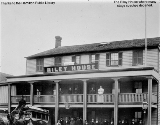
Four large horses were used to bring the stage from the Riley House at Main and West Streets, or the American Hotel located on John Street up to today’s West 5th street. The horses were changed at the Terryberry Inn west of Mohawk Rd., the present site of the Terryberry library. The teams would travel down the Mohawk Trail to the current Upper James Street which was then the Plank Road to Caledonia. The mud on the road was so bad in the spring and fall that it was almost impossible for passengers not to comment about it. In some places the mud was so deep the coaches would sink to their hubs and the passengers had no other choice but to get out and walk the rest of the way to Caledonia.
There were four toll booths between the mountain brow and Ryckmans Corners, however, to avoid paying tolls, coaches often detoured around them.
In those days it seemed everyone owned a tavern, hotel, or some form of drinking establishment. No less than 15 hotels or Inns lined the plank road from the edge of the mountain to the Grand River. Ryckmans Corners alone, had eight hotels and they each made good money. Ryckmans Corners was named for a former Pennsylvanian farmer and land surveyor. He received a government land grant for seven hundred acres (283 hectares) as payment for his services.
Over time the plank road improved considerably. Passengers would leave early in the morning for stops to Ryckmans Corners, Mt. Hope, Caledonia, Ballsville (a kilometer north of Hagersville), Hagersville, Garnet, known then as the village of St. Gust later Hullsville. Then onto Jarvis at Highway 3, where they would meet up with the Talbot Stagecoach. For this reason, Jarvis became the community that it is today.
Highway 6 passed through Mount Hope until April 26, 1956. Because they could not widen the original highway, they built the current bypass.
The road proceeded through Caledonia, crossing the Caledonia Bridge, which was built concurrently with the plank road. Before the current bridge, there were two bridges. The Grand River was first crossed by a wooden swing bridge, which allowed boats to move up and down the river. A six-span iron bridge was built in its place in 1875 and was used until the early morning hours of August 24, 1925, when a big truck crossed it. The vehicle and driver were thrown thirty feet into the Grand. The driver escaped unharmed. They constructed the current concrete bridge in 1927, and it is still the only operable nine-span bridge in Canada. Until 1929, each horse team and automobile that crossed the river paid a toll of two pence for a one-day return journey. It would cost a penny each way to stroll across the Grand River.
Almost immediately after the plank road opened Highway 6 became a major route for farmers from Haldimand and Norfolk counties to get their produce to the Hamilton Farmers’ Market.
In the 1970s and early 1980s, Highway 6 through Caledonia grew crowded with truck traffic and people traveling through town on their way to work at the Nanticoke Industrial Park. To alleviate traffic congestion, the Caledonia Bypass was created and Highway 6 through Caledonia became Argyle Street.
Port Dover grew from a tiny lakeside village to a small town thanks to the Port Dover to Hamilton Plank Road. However, Dover was not the destination that some of the initial users of the plank road had in mind.
Dogs Nest was a tiny hamlet located between Jarvis and Port Dover. For a moment in time, it had more log cabins than Port Dover, plus a busy little tavern. There are at least three versions of how this little hamlet got its name and all three versions involve puppies being born at the tavern and the tavern and in turn the nameless hamlet eventually became known as Dogs Nest. The tavern was a popular little spot in its day, local hunters would gather for some tall hunting tales and a little ale after a good outing. Soon word of mouth got around, and the place became the destination of hunters from Hamilton who travelled out by stagecoach. They used the stop as their starting point and the end of their hunting exhibitions.
During the War of 1812, Port Dover served as a key position for the British. It was incorporated as a village in 1835. By the late 1850s, the town of Port Dover had a population of 600 inhabitants. The tourist industry began in the 1880s, when prominent residents from the town of Simcoe began erecting cottages along the lake’s shores. By the 1900s, the majority of cottage owners were from Brantford or Hamilton.
Shenango No. 1 was the first ferry service out of the docks of Port Dover. It ferried passengers, automobiles, and rail freight to and from Conneaut, Ohio, starting on August 22nd, 1895. Hamiltonians rode their horses and buggies or drove their early automobiles up Highway 6 to Port Dover, where they caught the steamer’s Erie or the Keystone to Erie, Pennsylvania or Cleveland, Ohio. The Keystone itself could carry up to 1,000 passengers and eighty cars. The vessels became popular, taking tourists to the great shopping and entertainment centers across the lake. A fire in 1930 destroyed the Erie while mechanical problems plagued the final season of the Keystone in 1931. I purposely left out the City of Dover as I haven’t found any concrete evidence of it ferrying passengers beyond 1921.
The Erie and the Keystone were active on the Great Lakes well before the prohibition and the temperance movement. It became popular to travel up Number 6 highway to Port Dover, then across the lake to the many underground drinking establishments called speakeasies. Because Port Dover was considered a small port, border guards rarely bothered to check the passengers for booze. Smuggling alcohol became the next big thing, smugglers often used the ferries to get their ‘hooch’ across the border by hiding their liquor in fake bottoms built into baby buggies. Ladies would sew their dresses in such a way to as to conceal a bottle or two of liquor. Often, the men would crowd together and create concealed niches aboard the ships to hide their bottles as they sailed across Lake Erie.


